 |
 |
|
|
Date of Incorporation — August 10, 1909 as an incorporated village. In November 1967 Athol became an incorporated city in accordance with the requirements of the new state law.
Current Population — 695 as of 2014; 741 as of 2016 (U.S. Census population estimates)
Population Growth — The population of Athol in 1960 was 214, in 1980 was 312 and by 2000 it reached 676. It increased by 2.4 percent from 676 in 2000 to 692 in 2010 (U.S. Census). The city’s population stabilized at around 700 ever since. The depression reduced Athol's importance, and the community declined until the 1940s when Farragut Naval Training Station opened. The naval base to the east of the city brought in many workers and sailors. The naval base reached its peak during the Second World War, training over 293,000 during its 30-month period of existence. It was also used as a prisoner of war camp, and housed nearly 900 Germans who worked as gardeners and maintenance men. It was closed in 1949 and is now a small research facility. Athol has seen very little change since. A few short periods in the 1970’s and 80’s the potential for new growth is now being explored since the rerouting of the local U.S. Highway 95, which bypasses the current city limits. A number of projects are being reviewed and in the first stages of discussion and development; Forecasted projects that will impact the City are uncertain at this time.
Location and Description — The City of Athol is located in northern Kootenai County, Idaho. The Silverwood theme park is located in close proximity to the south. Athol is 4 miles west of Farragut State Park which is at the southern end of the Lake Pend Oreille. The city of Coeur d’ Alene is about 25 miles south of Athol, the city of Sandpoint is about 26 miles north. Spirit Lake is about 7 miles to the west of the city and Bayview is about 8 miles to the east. State Highway 54 intersects in the city, with State Hwy 95 running north and south. Athol is at the crossroads to them all. Farmland and forested areas surround the city, Coeur d’ Alene National Forest is accessible a few miles east and south of the city. Athol is located at 47°56'46"N 116°42'26"W / 47.94611°N 116.70722°W / 47.94611; -116.70722 (47.946024, -116.707349). According to the United States Census Bureau, the city has a total area of 0.8 square miles (2.0 km˛), all of it land.
Brief History — Until the early 1800s when explorers/trappers began coming into the area, American Indian-primarily of the Coeur d’ Alene and Spokane Tribes- had exclusive use of the land as they migrated through the region en route to their encampments near the area’s many lakes and streams.
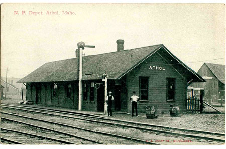
All this changed when the Northern Pacific Railroad station was built in Athol in 1882, and settlers hoped for a vast agricultural paradise. The depot was established in Athol on its line between Hauser Junction and Sandpoint. In 1895 town residents, mostly railroad employees and then homesteaders, successfully petitioned postal authorities for a post office. The white pine forest first attracted early settlers to Athol, and logging, milling, and agriculture created prosperity. However, the location of the new community was on state lands. In 1903, lots in Athol were auctioned by the state. State surveyors platted the new township but, apparently, did not record the change in ownership. For many years, the town’s residents did not have title to their land. Eventually the state corrected the problem.
Athol was first known as Colton, the town was renamed Athol by a settler who came from Athol, Massachusetts. The Massachusetts Athol was named after a town in Scotland named for the Duke of Atholl. No one knows for sure if Athol, Idaho was named by a descendent of the same family or if the name was just brought west during the 19th Century.
In 1900 the Methodist congregation built a church that also served as a school until 1902 when school patrons built their first school building. In December 1902 Hackett & Wilson opened a sawmill near the city. The mill became the city’s largest employer and had the capacity of producing 25,000 board feet of lumber per day. By 1903 there were many businesses opened, including the Pacific Hotel, a drugstore, a smithy, a jewelry store, restaurants, a mercantile company, and a saloon.
Athol’s first water well was dug by hand by Joe Pricsha and his crew. It was 350 plus feet deep. They dug into a large boulder, so they had to dig around it, which made a curve in the shaft. A 5hp pump motor was installed, which supplied the town with water. Later, another shaft with a larger pump was installed in the same hand-dug hole.
Athol Today — Two state parks are nearby. The 4,000 acre Farragut State Park is four miles east, and the 142 acres Round Lake State Park is about ten miles north. Two miles south is Silverwood Theme Park, the Northwest’s largest Theme park. This is a privately owned park and has over 70 rides, shows and attractions including four roller coasters and Boulder Beach Water Park.
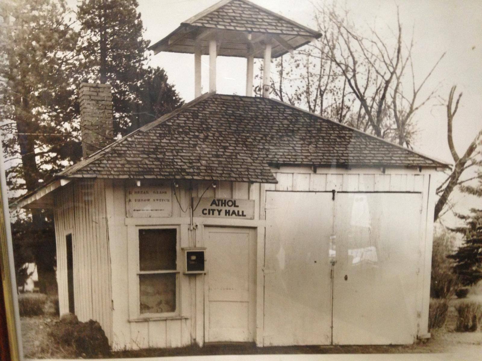
Governing Body Format — The City is governed by a mayoral/council form of government with four City Council Members and a Mayor, all of which are elected to 4 year terms. This body will assume the responsibility for the implementation and adoption of this plan. The Mayor oversees the day-to-day operations of the City. Services provided by the City include Public Services including Public Works, Cemetery, Road Maintenance, City Park & Playfields, and Water. The city employs 2-3 full-time positions, and utilizes a lot of volunteer and community service workers.
Economy and Major Employers — Lakeland School District, Idaho Forest Group, and Super 1 Foods are the city’s largest employers. Most residents commute to nearby larger cities to work and shop. There are approximately 25 plus smaller local businesses operating in the city.
Education — Lakeland School District provides the public education in the city. Elementary students attend Athol Elementary. Middle and Senior high school students attend school about seven miles east in Spirit Lake. The closest institution for higher learning is North Idaho College in Coeur d’ Alene.
Utilities and Services — Private companies provide electricity, telephone, internet/TV, and gas services. The city provides street and water services. Policing is contracted with Kootenai County, and Timberlake Fire District covers the area for fire protection.
Vision for 2050 — The city is working on rebuilding and re-accessing its needs and assets after the passing of the Mayor, whom served for 19 years, in January 2014. The new leadership led to the reveal of the embezzlement occurring by the then city clerk, S. Hansen. She was convicted of 11 counts of wire fraud, for stealing over $400,000 in a five-year time. In light of this crime, city elected officials and the citizens are keeping a much closer eye on city funds. A new vision and new direction for the city is to update the comprehensive plan and city codes as well as address current and future city infrastructure and its needs. They hope the community can come together to proactively make decisions that will help shape the future direction of the city and create a new vision to better identify what the future of the Athol should look like.